
Why Property Line Markers Should Never Be Used as Digging References
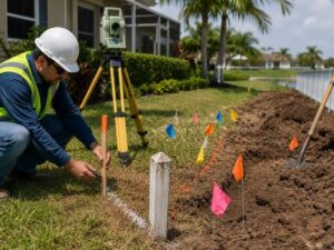
Property line markers look like a simple guide for where to dig. They are not. A boundary survey confirms exact legal lines, but a marker alone can sit inches or feet from where you think it does, and that gap can turn a simple project into an expensive mistake.
This guide covers why markers make a poor digging reference on their own, and what steps protect your project instead.
What a Property Line Marker Actually Tells You
A Point, Not a Full Picture
A marker shows one corner or point along a boundary. It does not show underground utility lines, easement widths, or setback distances. Treating it as a full map of what is safe to dig near skips most of the information you actually need.
Markers Can Shift Over Time
Landscaping, mowing, and old construction work can move or bury a marker without anyone noticing. A boundary marker sitting in the wrong spot still looks official, which makes it easy to trust even when it no longer reflects the true line.
Why Digging Near a Marker Alone Is Risky
Utility Lines Do Not Follow Property Lines
Underground utility lines often run at odd angles, curve around obstacles, or sit closer to one side of a lot than expected. A marker gives no information about where these lines actually run beneath the surface.
A Few Inches Can Mean a Costly Mistake
Hitting a utility line during digging can cause an outage, a repair bill, or a safety hazard. Assuming a marker marks a safe digging zone, when it only marks a boundary corner, is how many of these incidents start.
Legal Boundary Confusion Can Follow
If a marker has shifted or was never accurate to begin with, digging based on it can lead to work happening on the wrong side of the real property line. This can create a dispute with a neighbor even after the project is finished.
What a Boundary Survey Adds That a Marker Cannot
Confirmed Legal Lines, Not Just Visual Points
A boundary survey ties every corner to confirmed legal measurements, not just a physical object sitting in the yard. This gives you a full, accurate outline of the property, not a single reference point guessed at from a marker.
A Record You Can Actually Rely On
A current survey document gives you something a marker alone cannot: a paper record confirming exact distances and angles. This matters if a dispute or permit question comes up after your project is already underway.
Steps to Take Before Any Digging Project
Call for a Utility Locate First
Before any digging, contact your local utility locate service so crews can mark underground lines with flags or paint. This step exists specifically because property lines and utility paths do not always match up.
Confirm Boundary Lines With a Current Survey
If your project sits near a property line, a current boundary survey confirms exactly where that line falls, rather than relying on an old marker that may no longer be accurate.
Compare Utility Marks Against Survey Data
Once utility lines are marked and your survey is in hand, compare the two before digging. This step catches conflicts between planned work and underground lines before equipment touches the ground.
Who Should Be Involved Before Ground Gets Broken
Bringing In a Licensed Surveyor Early
A licensed surveyor does more than confirm a boundary line. They can also flag old markers that look suspect, note recent disturbances near the property edge, and confirm whether existing documentation still matches current conditions. Bringing them in before design work starts saves time later.
Keeping Contractors Informed of Survey Results
Once a survey and utility locate are complete, share both documents with anyone doing physical work on site. A contractor working from outdated information, even with good intentions, can still dig in the wrong spot if nobody passed along the confirmed data.
Documenting Everything Before Work Begins
Keep copies of the survey report and the utility locate confirmation on file before any digging starts. If a dispute or damage claim comes up later, having both documents on hand makes resolving the issue much faster.
Common Situations Where This Mistake Happens
Fence Installation Projects
Many fence projects start with someone eyeballing a marker and digging post holes nearby. Without checking a current survey or requesting a utility locate, this quick approach can put posts on the wrong side of the line or directly into a buried line.
Small Additions and Landscaping Work
Sheds, retaining walls, and landscaping beds near a property edge often skip formal boundary checks since the work feels minor. Small projects still carry the same underground risk as larger ones, and a marker still tells you nothing about what sits below the surface.
Shared Driveway and Access Point Work
Projects involving a shared driveway or access easement often involve digging close to a boundary line shared with a neighbor. This situation raises the stakes further, since a mistake here can affect two properties instead of one.
A Pre-Digging Safety Checklist
- Contact the utility locate service before any digging begins
- Confirm boundary lines with a current survey, not just visible markers
- Compare utility markings against survey data for the planned dig area
- Avoid assuming a marker reflects exact legal boundary distances
- Document survey and utility locate results before work starts
Protecting Your Project From an Easy Mistake
A property line marker gives you a rough sense of where a boundary sits, nothing more. Pairing a current boundary survey with a proper utility locate protects your project from costly digging mistakes that a single marker was never designed to prevent.
Frequently Asked Questions
Can a property line marker move without anyone noticing?
Yes. Landscaping work, mowing equipment, or old construction can shift or bury a marker over time. A marker that looks intact does not guarantee it still sits in its original, surveyed position.
Does calling a utility locate service replace the need for a boundary survey?
No. A utility locate marks underground lines, while a boundary survey confirms legal property lines. Both serve different purposes, and a digging project near a property line often needs both steps completed.
Why do underground utility lines sometimes run at odd angles compared to property lines?
Utility lines are often installed based on the easiest or most direct path for service, not based on property boundaries. This means they can curve, angle, or run closer to one side of a lot than expected.
What should a developer do if a marker and a survey do not seem to match?
Trust the current survey over the marker. If there is a clear conflict, contact a licensed surveyor to confirm the correct boundary before any digging or construction work continues.
Is it common for property owners to assume a marker shows a safe digging zone?
Yes, this is a common assumption, largely because a marker looks official and permanent. In reality, it only confirms one boundary point and says nothing about what lies underground nearby.
For a free land surveying quote, call us at (954) 250-5780 or send us a message by going here.
Posted in land surveying, land surveyor | Tagged Boundary Survey, Boundary Surveyor