
When an Elevation Survey Becomes a Design Requirement
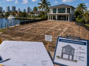
Fort Lauderdale sits low. Much of the city sits close to sea level, next to canals, or near tidal water. That’s why an elevation survey often stops being optional here. It turns into a design requirement the moment you start planning a project. Skip it and you risk a redesign, a rejected permit, or a foundation poured too low to meet code.
This article walks through when that shift happens. It also covers how the survey changes your design once you have it in hand.
If your lot sits in a flood zone, near water, or in an area with strict freeboard rules, order the elevation survey before you draw a single foundation plan. It sets the numbers everything else depends on.
What Triggers the Need for an Elevation Survey
Not every project in Fort Lauderdale needs an elevation survey. But most do. The reasons come down to where the lot sits and what you plan to build.
Flood Zone Maps and Permit Reviews
If your parcel sits inside a Special Flood Hazard Area, the city will ask for elevation data before it approves your plans. Broward County reviewers check flood zone status early, often before anything else. If that data is missing or outdated, your permit stalls right there. You lose weeks waiting for a resubmittal.
Base Flood Elevation and Freeboard Rules
Every flood zone carries a Base Flood Elevation, known as the BFE. That number shows how high floodwater is expected to reach during a major storm. Fort Lauderdale also adds freeboard on top of that. This is extra height meant to protect homes beyond the federal minimum. Your design has to clear both numbers. You can’t guess them from a flood map alone. You need field data tied to the real ground on your lot.
New Construction Versus Additions and Renovations
New builds almost always need an elevation survey. The city has to know where the ground sits before it approves a fresh foundation. Additions and larger renovations often need one too, especially if you’re expanding the footprint or raising part of the structure. Small interior remodels usually skip this step, since they don’t touch elevation or footprint.
How Elevation Data Shapes Site Design
Once the survey is done, the numbers drive real decisions. They aren’t just paperwork sitting in a permit file. They shape how your architect and engineer approach the site from day one.
Setting Finished Floor Height
Your architect uses the survey to set the height of your first floor. Get this wrong and you pay for it. Build too low and you risk flood damage along with higher insurance costs. Build higher than needed and you spend extra money on foundation work the code never required.
Grading and Drainage Plans
Civil engineers use the same elevation points to plan how water moves across your site. A poorly graded lot can send stormwater toward the house instead of away from it. That kind of mistake traces back to a design choice, not bad luck during a storm. Getting the survey early gives your engineer real ground data to grade the site correctly the first time.
Foundation Type Decisions
Low ground often calls for something other than a standard slab. Pilings, elevated slabs, and breakaway wall systems all come into play depending on how close your lot sits to the base flood elevation. The survey tells your team which approach fits your site, instead of leaving that choice to guesswork.
Fort Lauderdale Specific Considerations
Local geography adds extra weight here. It helps to understand why before you assume a survey from another region will cover you.
Low Elevation and King Tides
Parts of Fort Lauderdale see nuisance flooding during king tides, even without rain. An elevation survey shows how close your lot sits to that risk. A generic flood map often can’t capture that level of detail.
City and County Freeboard Requirements
Fort Lauderdale and Broward County have both set freeboard standards that go beyond the federal baseline from FEMA. Your design has to meet local rules, not just the federal minimum. A surveyor who knows the local code will flag this early, before it becomes a problem during permit review.
Barrier Island and Canal Lots
Waterfront and canal lots face tighter scrutiny than land further inland. Seawalls, tidal shifts, and soil conditions near the water all affect elevation data in ways inland lots don’t face. A survey pulled from another part of the state won’t capture these local factors well.
Timing: When to Order the Survey
Timing matters as much as accuracy. Order the survey too late and it can undo months of design work.
Order a preliminary elevation check before you close on raw land. It can reveal costly grading or foundation needs before you’re locked into the purchase. Once design starts, give your architect the elevation data before schematic drawings begin. Redesigning after the fact wastes time and money. Before you submit for permit, make sure the elevation data on your plans is current. Old data, even if it was accurate once, tends to get rejected by reviewers who want something tied to today’s flood maps.
What Happens If You Skip It
Skipping the survey doesn’t save time. It just moves the cost to a later, more painful point in the project.
Permit reviewers send plans back when elevation data is missing, which resets your review clock. Architects guess at floor heights without real numbers, then redo drawings once the survey finally shows up. Contractors sometimes pour a foundation at the wrong height because nobody caught the error first. Insurance costs climb when the finished elevation ends up lower than it should be. Buyers or lenders often ask for a survey anyway at closing, so the cost shows up eventually either way.
Working With a Licensed Surveyor
Not all elevation data is equal. A quick phone estimate isn’t the same as a real field survey. Ask for current ground elevations recorded at multiple points across the lot, not just one reading near the front. Make sure the data includes the elevation at your base flood elevation reference point, since that’s the number your design has to meet. Confirm the survey uses the right vertical datum, which in Florida is usually NAVD88. Get a written certification your engineer and the permit office can use directly, without follow-up questions.
Bringing It Into Your Project Timeline
Treat the elevation survey like utility locates or soil testing. It belongs in due diligence, not tacked on right before permitting. Bring your surveyor in as soon as you have a site under contract or control. That gives your design team real numbers from day one, instead of placeholders that need fixing once the actual survey comes back.
Frequently Asked Questions
Do I need an elevation survey for a home addition?
In many cases, yes. An elevation survey may be required when expanding a home’s footprint, particularly if the property is located within or near a flood zone. Check with your local building department or design professional to determine the requirements for your project.
How is an elevation survey different from a boundary survey?
A boundary survey establishes the legal property lines and identifies existing improvements relative to those boundaries. An elevation survey measures the height of the ground and structures relative to an established vertical datum. Many construction projects require both surveys.
What vertical datum is commonly used for elevation surveys?
Most elevation surveys in the area reference the North American Vertical Datum of 1988 (NAVD 88). However, project requirements can vary, so it is important to confirm the required datum with your surveyor and the reviewing agency before submitting plans.
Can I use an older elevation survey for a new building permit?
Not always. Changes to site conditions, flood maps, or local regulations may require updated elevation information. Many permitting authorities prefer or require a current elevation survey before approving new construction or additions.
Who typically pays for an elevation survey?
Responsibility depends on the project and the agreement between the parties involved. Property owners often obtain an elevation survey during planning or permitting, while builders or developers may order one as part of the construction design process.
For a free land surveying quote, call us at (954) 250-5780 or send us a message by going here.
Posted in land surveying, land surveyor | Tagged Elevation Survey