
Why Some Subdivision Surveys Take Longer Than Expected
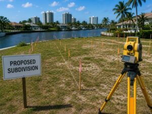
Infill lots are getting split, combined, and re-platted all over Fort Lauderdale right now. Subdivision surveys sit at the center of that work. Yet developers keep hitting the same wall: the survey takes longer than the schedule allowed. Deals stall. Closing dates slip. Contractors sit idle waiting on a plat that hasn’t been recorded yet.
This article breaks down why that happens and what you can do about it.
Subdivision surveys rarely take longer because of bad surveyors. They take longer because of things outside the survey itself: old records, utility conflicts, and county review queues. Plan for those delays up front and you’ll protect your timeline.
What a Subdivision Survey Actually Involves
A subdivision survey splits one parcel into two or more legal lots. It’s not just measuring and drawing lines. The surveyor has to research old deeds, check flood zones, confirm access, and prepare a plat that Broward County will accept for recording.
That last part is where most delays start.
Common Reasons Subdivision Surveys Run Long
Title and Deed Research Problems
Older Fort Lauderdale properties often have messy deed history. Lot lines described decades ago don’t always match today’s aerial imagery or fence lines. When gaps or conflicts show up, the surveyor has to stop and research further before drawing a single new line. This step alone can add weeks.
Utility and Easement Conflicts
Infill lots often carry old easements for utilities, drainage, or access that were never cleaned up. A new subdivision plat has to account for every one of these. If a utility company hasn’t updated its records in years, getting written confirmation can take longer than the fieldwork itself.
County Plat Review Cycles
Broward County reviews subdivision plats in cycles, not on demand. Submit your plat the day after a review deadline and you might wait weeks for the next slot. Comments come back, changes get made, and the plat goes through another round. Two or three review cycles is normal, not rare.
Flood Zone and Drainage Requirements
Many infill parcels in Fort Lauderdale sit in flood zones or areas with strict stormwater rules. Subdividing a lot can trigger new drainage calculations or retention requirements. That means extra engineering work has to finish before the plat can move forward.
Access and Right of Way Issues
New lots need legal access to a public road. If the original parcel had one driveway serving the whole property, splitting it might require new easements or dedicated right of way. Negotiating that with neighbors or the county adds real time.
How Infill Development Adds Extra Layers
Fort Lauderdale’s infill boom means smaller, oddly shaped, and older parcels are getting subdivided more than ever. These lots come with baggage that fresh, large-tract land doesn’t have.
- Older survey monuments that no longer exist in the field
- Structures built close to or over old lot lines
- Mature trees or landscaping that affect setback and access calculations
- Neighboring owners who dispute where the line actually sits
Each of these can turn a routine subdivision into a research project.
What Developers Can Do to Avoid Delays
You can’t control county review speed. You can control how prepared your project is before the survey even starts.
Order Title Research Early
Get a title search done before you hire a surveyor. Handing the surveyor clean title history from day one saves real time later.
Confirm Utility Records in Advance
Reach out to utility providers early and ask about existing easements on the parcel. Don’t wait until the plat is drafted to find out there’s a conflict.
Ask About Flood Zone Status Before Design
Check the flood zone designation before your civil engineer starts drainage design. Changing plans mid-process after a plat submission adds weeks.
Build Buffer Time Into Your Schedule
Assume two to three county review cycles, not one. If the plat clears faster, great. If you planned for one cycle and it takes three, your whole project timeline falls apart.
Choose a Surveyor Who Knows Local Review Staff
A surveyor who regularly submits plats to Broward County knows what reviewers flag most often. That experience alone can cut a review cycle or two off your timeline.
A Realistic Subdivision Timeline
Here’s a rough sense of what to expect on a typical infill subdivision in Fort Lauderdale, assuming no major conflicts:
- Title and records research: 1 to 3 weeks
- Field survey and drafting: 2 to 4 weeks
- Utility and easement confirmation: 2 to 6 weeks, often running in parallel
- County plat review (per cycle): 3 to 6 weeks
- Recording after final approval: 1 to 2 weeks
Add it up and a clean subdivision can still take three to four months. A complicated one with conflicts can run past six.
Working the Process, Not Fighting It
Subdivision surveys aren’t the bottleneck most developers assume they are. The bottleneck is everything feeding into them: unclear title, undocumented easements, flood zone questions, and county queues. Start those pieces early and the survey itself moves at a normal pace.
Frequently Asked Questions
How long does a subdivision survey take in Fort Lauderdale?
The timeline depends on the size and complexity of the project. A straightforward subdivision may take several months from the initial survey through final plat recording, while projects involving title issues, utility conflicts, or additional agency reviews can require more time.
Why does Broward County’s plat review process take time?
Subdivision plats are reviewed through an established review process that involves multiple departments and scheduled review cycles. If revisions are required or submission deadlines are missed, the approval timeline may be extended.
Can I speed up the subdivision survey process?
In many cases, yes. Providing existing title documents, confirming utility easements, and resolving known property issues before the survey begins can help reduce delays and keep the project moving through the review process more efficiently.
Do all subdivided lots require new drainage calculations?
Not always. Whether updated drainage calculations are required depends on the scope of the subdivision, local regulations, and site conditions. Projects located in flood-prone areas or involving significant site changes are more likely to require additional stormwater analysis.
What is the difference between a subdivision survey and a boundary survey?
A boundary survey identifies the legal limits of an existing parcel. A subdivision survey goes a step further by dividing that parcel into new legal lots and preparing the documents needed for review, approval, and the recording of a subdivision plat.
For a free land surveying quote, call us at (954) 250-5780 or send us a message by going here.
Posted in land surveying, land surveyor | Tagged Land Surveying