
How Drone LiDAR Mapping Helps Spot Drainage Trouble Before Design Starts
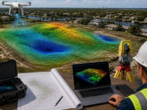
Drone LiDAR mapping catches drainage problems while they are still cheap to fix. It does this before a single drawing leaves the engineer’s desk. This timing matters most on flat ground near tidal water. Flat land hides drainage flaws better than almost any other terrain. There is no slope to give the problem away. A shallow, porous layer below the surface adds more risk, since rain does not always drain the way it would on higher ground.
A LiDAR scan before the stormwater design starts means the design rests on what the land actually does, not on what it looks like it does. That one shift in timing can change the entire outcome of a project.
Why Timing Changes the Outcome
Most developers think of LiDAR as a tool for documenting a site after the fact. It works far better as a tool for shaping the design from the start. Order the scan before the engineer drafts a stormwater plan, and the data shapes every choice from day one. Order it after the engineer draws the plan. Then you end up checking someone’s guesses instead of giving them better facts to begin with.
Here is what often happens when LiDAR comes too late. An engineer builds the drainage plan on a rough topo map or an old survey. The engineer routes runoff toward what looks like the low point on the lot. Construction starts soon after. Then a real storm shows water pooling somewhere nobody planned for. The design was never checked against true elevation data in the first place. Fixing that problem after groundbreaking costs far more than catching it on a contour map months earlier.
Why Flat, Tide-Influenced Ground Needs This Extra Step
Flat land does not forgive guesswork. A half-inch difference in height can decide which way water moves across a lot. On flat ground, the human eye cannot tell a gentle half-inch slope from a flat surface. Some coastal areas sit on shallow, porous ground with miles of canal-lined shoreline. This kind of land hides drainage flaws better than almost any other type.
Flooding in many coastal markets is not only about rain. King tides can push water levels up from canals and inlets. When that timing lines up with heavy rain, drainage systems built around rain alone can fall short. Many coastal cities name specific flood-prone neighborhoods in their stormwater plans for this exact reason. A site-specific LiDAR scan will not model tidal surge on its own. It does give the engineer the true ground heights needed to see how a property sits next to known flood-prone zones nearby.
High water tables add another problem for standard design choices. Shallow, porous ground means rain does not always drain the way a textbook model expects. Groundwater rises during heavy rain, which leaves less room in the soil to soak up runoff. Detailed elevation data lets an engineer plan for this. It replaces guesswork about standard soak rates that may not hold up on this kind of ground.
What LiDAR Reveals Before Design Starts
A flat lot can still hide a shallow dip that holds water after every storm. LiDAR’s dense point cloud catches these low spots even when they stay hidden during a normal site walk. This matters because a hidden dip near a building pad can turn into a standing water problem the first time it rains hard.
Drainage design also depends on knowing how a site’s height compares to the lots around it. LiDAR captures that relationship with real accuracy. This matters when runoff needs to move away from a property without dumping it onto a neighbor’s land. Older neighborhoods often have swales, pipes, or catch basins that do not match what shows up on old record drawings. A LiDAR pass over the site helps confirm what is really there. Pair it with visible markers on the ground, and you know what the new design has to connect to before work starts.
Building the Scan Into Your Project Timeline
Order the LiDAR scan during due diligence, before you commit to a design direction. Share the raw data with your civil engineer early. Use it as a true design input from day one, not a final check. Ask for contour lines tight enough for real drainage work, usually one foot or less. Flag any tide-influenced areas nearby, so the engineer can factor nearby flood zones into the design. Keep the dataset on file too, since it stays useful later for permits and for as-built checks once construction wraps up. Many developers skip this step and end up paying for a fresh survey later, when the original scan could have covered it from the start.
What This Saves You Down the Line
A drainage redesign after construction starts costs more than just the redesign itself. It means sending crews back out, reworking finished grading, and absorbing delays that ripple through the rest of the project. A LiDAR scan ordered before design work begins costs a small fraction of that. It also gives your engineer something solid to design against, instead of a guess to design around. For coastal sites with flat land and tidal influence, that early data matters even more. It often makes the difference between a stormwater system that works on day one and one that needs a costly second look a year or two down the road.
Frequently Asked Questions
When in the project timeline should drone LiDAR mapping happen?
Drone LiDAR mapping works best during due diligence, before the civil engineer starts the stormwater design. This timing lets the design respond to real site conditions instead of forcing a check against them after the engineer has already drawn the plans. Waiting until after the design phase turns the scan into a check rather than a planning tool.
Can drone LiDAR mapping account for tidal flooding on its own?
No, it cannot. LiDAR captures ground elevation with great accuracy, but tidal surge modeling needs flood zone data and local tide data too. The two work together rather than standing in for each other.
How does drone LiDAR mapping help on flat sites specifically?
Flat sites hide small height changes that the human eye cannot catch on a normal walk through. LiDAR’s point density picks up small grade differences that decide which way water actually moves, something a standard ground survey can easily miss. That level of detail is hard to get any other way on land this flat.
Does LiDAR replace the need for a civil engineer’s drainage design?
No, it does not replace that work. LiDAR provides the elevation data that the design rests on. The engineer still handles the math, the modeling, and the full system design using that data as the base.
Is drone LiDAR mapping useful for smaller residential sites, not just large projects?
Yes, it is useful at almost any scale. Even a single lot benefits from accurate elevation data, especially on flat or low-lying ground where small grading mistakes can lead to costly drainage problems later on. Smaller sites often skip this step, but the same risks still apply.
For a free land surveying quote, call us at (954) 250-5780 or send us a message by going here.