How LiDAR Mapping Helps Spot Drainage Problems on Flat Properties
A property can look dry one day and turn into a mess after a single storm.
Water starts collecting near the house. Grass stays soaked long after the rain stops. Mud forms near fences and patios. Some owners even notice water creeping toward the foundation.
At first, the problem seems simple. Many people think the yard just needs better drainage pipes or a small trench. Then the flooding keeps coming back.
The real issue often starts with the shape of the land itself.
Even flat properties have small elevation changes. Those changes may only measure a few inches, but they still affect how water moves across the ground. That is why lidar mapping has become useful for drainage planning, grading work, and land development.
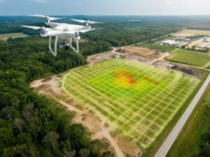
LiDAR mapping helps surveyors measure the surface of the land with far more detail than the human eye can see.
Why Flat Properties Struggle With Drainage
Steep hills make drainage easy to understand. Water flows downhill fast, and people can usually see where the runoff goes.
Flat land creates a different problem.
Water moves slowly across level ground. Instead of draining away quickly, it spreads out and settles into low areas. One shallow dip in the soil can trap water after every storm.
That is why flat properties often deal with:
- Standing water
- Soft ground
- Yard erosion
- Wet crawl spaces
- Foundation moisture
- Drainage near driveways and sidewalks
Many owners miss the warning signs early because the property appears level from the ground. The slope changes look too small to matter.
Water does not care if the change looks small.
It reacts to every inch of elevation.
What LiDAR Mapping Does
LiDAR mapping uses laser measurements to study the surface of the land.
Surveyors collect thousands of elevation points across a property using drones, aircraft, or ground equipment. Those points create a digital surface model that shows how the ground rises and falls.
The mapping process can reveal:
- Hidden low spots
- Drainage paths
- Uneven grading
- Areas where runoff collects
- Surface elevation changes
- Soil movement over time
Some properties look completely flat during a visual inspection. Then the lidar data reveals several shallow depressions that trap water during heavy rain.
That level of detail helps surveyors study drainage conditions before the problem becomes expensive.
Small Elevation Changes Create Large Problems
Many drainage issues start because of tiny grade differences.
One side of a driveway may sit slightly higher than the other. A patio may block runoff that once drained correctly. Fill dirt from an older construction project may have changed the natural slope of the yard.
Those changes seem minor until the rainy season arrives.
Water starts flowing toward the house instead of away from it. Low spots stay wet for days. Soil weakens around sidewalks and fences.
People often blame the storm itself. In many cases, poor grading caused the issue long before the rain started.
LiDAR mapping helps surveyors identify those grade changes early. That allows property owners to fix the source of the problem instead of guessing.
Construction Projects Often Change Drainage
Drainage problems commonly appear after construction work.
That includes:
- New homes
- Additions
- Pools
- Parking areas
- Retaining walls
- Large concrete driveways
A new structure changes how water flows across the property. Sometimes runoff gets redirected into neighboring yards. Other times, the soil no longer drains the way it did before construction started.
One grading mistake can affect several nearby properties.
That creates frustration fast, especially between neighbors.
LiDAR mapping gives builders, engineers, and surveyors a clearer view of existing drainage patterns before work begins. That makes planning easier and reduces the risk of future flooding problems.
Why Owners Miss Early Drainage Warning Signs
Drainage damage builds slowly.
At first, owners may only notice small puddles after heavy rain. Then the water starts staying longer. Grass begins dying in certain spots. Mold appears near exterior walls. Cracks form near walkways or driveways.
By then, water may already be affecting the property structure.
Flat land makes the issue harder to spot because the elevation changes look almost invisible from ground level. A yard may appear level while still directing runoff straight toward the foundation.
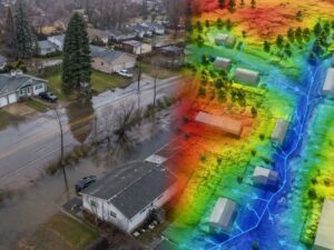
LiDAR mapping removes much of the guesswork. Surveyors can study exact elevation data instead of relying on visual estimates alone.
Hidden Low Spots Cause Repeated Flooding
Some drainage problems stay hidden for years.
The property may contain:
- A shallow depression in the yard
- Soil that settles unevenly
- Blocked runoff areas
- Poor grading near the foundation
Those conditions trap water repeatedly.
Walking across the property may not reveal the problem clearly. LiDAR mapping shows those hidden elevation changes through detailed surface data.
That helps surveyors identify:
- Where the water starts
- How runoff moves
- Where drainage slows down
- Where water finally collects
Without accurate mapping, many owners spend money fixing the wrong section of the yard.
Drainage Problems Can Lower Property Value
Standing water creates more than an ugly lawn.
It can damage:
- Foundations
- Sidewalks
- Pavement
- Landscaping
- Fences
- Crawl spaces
Buyers notice drainage issues quickly during inspections. Water near the foundation raises concerns about future repair costs.
That can delay property sales and reduce value.
Many owners focus on the visible damage while ignoring the actual drainage pattern causing the problem. LiDAR mapping helps identify the source before the damage spreads further.
Why Surveyors Use LiDAR Mapping for Drainage Work
Surveyors need accurate elevation information for drainage planning.
That information supports:
- Site grading
- Stormwater planning
- Construction preparation
- Flood prevention
- Land development
- Drainage corrections
Traditional field methods still matter, especially for boundary and construction work. Still, lidar mapping allows surveyors to study large areas faster while collecting detailed surface data.
That matters on flat land because small elevation shifts affect everything connected to drainage.
Water Always Finds the Lowest Point
That rule never changes.
The challenge is that people often cannot see the lowest point without proper mapping tools.
Flat properties create drainage problems because the elevation differences appear too small to notice from the ground. Still, water responds to every rise and dip in the surface.
LiDAR mapping helps surveyors measure those changes with far better accuracy. That gives property owners better information before drainage problems turn into major repair costs.
A drainage issue rarely fixes itself. In most cases, the problem spreads over time. Wet soil weakens structures. Water reaches areas where it should never sit. Then repair costs start climbing.
That is why many builders, engineers, and property owners use lidar mapping before starting grading work or drainage repairs. Accurate elevation data helps them understand how the property actually handles water during heavy rain.
Without that information, people often spend money treating symptoms instead of fixing the source.
A property may need regrading. Another site may need better runoff control near the driveway. Some yards simply have hidden low areas that trap water after storms. Every property is different, but the first step stays the same: understand the surface before making changes.
LiDAR mapping gives surveyors a clearer picture of how water moves across the land. That helps property owners make smarter decisions before drainage damage becomes harder and more expensive to fix.
For a free land surveying quote, call us at (954) 250-5780 or send us a message by going here.
Posted in land surveying, land surveyor | Tagged LiDAR mapping