Why a Boundary Survey Matters Before Buying Near a Redevelopment Corridor
 A boundary survey before buying near a redevelopment corridor isn’t a formality. It’s the one document that tells you what you’re actually getting, what the city can take, and what you can build before you hand over a single dollar.
Redevelopment corridors change fast. Road widening projects, transit expansions, and utility upgrades get layered onto existing parcels. What looks like a clean, buildable lot on paper can have a chunk already spoken for by a government right-of-way. Without a current boundary survey, you won’t see that coming until after closing.
Redevelopment Corridors Carry Hidden Risks
Active redevelopment zones attract investment for good reason. Zoning gets updated. Infrastructure improves. Property values move. But those same forces create real risks for buyers who skip due diligence on the physical boundaries of what they’re purchasing.
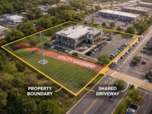
Road widening is the most common problem. A city plan to expand a corridor by 10 or 15 feet can cut directly into a parcel’s buildable area. That taking may already be recorded in county or municipal documents. It won’t show up on the listing or the seller’s disclosure. A boundary survey pulls existing right-of-way dedications, easements, and encumbrances into the picture before you commit.
Utility corridors are another issue. Sewer main expansions, stormwater upgrades, and buried utility relocations often run through private parcels. An easement for a utility line can restrict what you build and where. Sometimes permanently.
What Gets Recorded Versus What Gets Noticed
The Plat Map Problem
Most buyers rely on the recorded plat as the full picture of a parcel. Plat maps show original lot lines from when a subdivision was created, sometimes decades ago. They don’t always reflect right-of-way dedications, lot line adjustments, or easements recorded after the fact.
Near a redevelopment corridor, the gap between what the plat shows and what’s actually encumbered can be large. A boundary survey reconciles the plat with the current record. That includes anything filed after the original subdivision was recorded.
Old Documents That Never Got Updated
Deed restrictions, utility easements, and drainage agreements recorded years ago stay attached to a parcel. They don’t expire just because the neighborhood changed around them. Near active redevelopment corridors, older easements for drainage or utility access often conflict with new development plans.
A boundary survey locates and maps those encumbrances. Your design team needs that information before any plans are drawn.
Setback Math Goes Wrong Without Accurate Lines
Setback requirements are calculated from the property line. If you don’t know exactly where the property line is, you can’t calculate setbacks correctly.
A parcel that looks like it has room for a five-story mixed-use building may not. That becomes clear only after the actual boundary is established and current setback rules are applied.
Near redevelopment corridors, zoning changes often happen in stages. A parcel might sit inside a new transit-oriented development overlay with different setback rules than before. Combine that with a reduced lot size from right-of-way dedications, and the buildable envelope can shrink fast.
Finding that out during design saves real money. Finding it out during permitting does not.
Title Insurance Has a Gap Most Buyers Miss
Standard title insurance protects against defects in the ownership chain. It does not protect against boundary disputes, encroachments, or easement locations that a physical survey would reveal. Those are survey exceptions. They appear in nearly every title commitment.
A buyer who closes without a current boundary survey is accepting that exception. That means if a neighboring structure sits on your parcel, or an access easement cuts across your best corner, the title policy won’t cover the cost of fixing it.
Near active redevelopment corridors, construction activity is high. Encroachments are common. Accepting that exception here carries more risk than it would on a quiet residential street.
New Encroachments Appear Fast in Active Construction Zones
Active construction in redevelopment areas means equipment, fencing, and staging areas show up constantly. Sometimes they don’t leave. A concrete pad poured during a neighboring project can end up partly on your parcel. A fence put up for site security may stay standing long after the project wraps.
Over time, that kind of encroachment creates legal exposure. A boundary survey done before closing documents existing conditions. If something is already on the property before you buy it, you inherit that problem. The survey gives you the chance to address it with the seller before the deal closes.
What a Boundary Survey Actually Catches Near a Redevelopment Zone
A licensed Professional Surveyor and Mapper (PSM) completing a boundary survey near a redevelopment corridor will look for and document:
- Recorded right-of-way lines and any future dedications already filed with the county or city
- Utility easements, drainage easements, and access easements recorded against the parcel
- Physical encroachments from adjacent properties or public infrastructure
- Gaps between the legal description in the deed and the actual physical boundary
- Evidence of use or occupation that differs from the record boundary
Each item on that list can change what you’re allowed to build or reduce the parcel’s value below what you paid.
Order the Survey Before the Contingency Window Closes
The right time to order a boundary survey is during the due diligence period, before the inspection contingency expires. That gives you time to review the results. You can renegotiate the price, ask the seller to clear encumbrances, or walk away if the issues are too serious.
Ordering the survey after closing means you absorb whatever problems exist. Developers who skip the survey during due diligence and find boundary issues during permitting face redesign costs and permit delays. In some cases, the project gets canceled on a parcel they’ve already paid for.
Frequently Asked Questions
What does a boundary survey show that a title search doesn’t?
A title search reviews the ownership chain and recorded documents. A boundary survey physically locates the property lines on the ground. It shows encroachments, where easements actually sit on the parcel, and any gap between the legal description and the physical boundary. Both catch different problems. Near a redevelopment corridor, you need both.
Can I rely on a prior owner’s boundary survey for a parcel near a redevelopment zone?
A prior survey may be outdated. Right-of-way dedications, new easements, and adjacent construction can change conditions fast near active corridors. A survey that’s more than a few years old may not reflect current encumbrances. Getting a new survey tied to current records is the safer call for any significant purchase.
What is a right-of-way dedication and how does it affect my parcel?
A right-of-way dedication transfers a strip of private land to a government entity for road, sidewalk, or utility use. Once dedicated, that portion of the parcel is no longer yours to build on. Near redevelopment corridors, future right-of-way dedications are sometimes already recorded before construction begins. A boundary survey identifies those dedications and shows how much of the parcel is affected.
Does a boundary survey cover zoning changes near a redevelopment corridor?
No. A boundary survey documents the physical boundary and recorded encumbrances. It doesn’t replace a zoning review. For parcels near redevelopment corridors, you need both. The boundary survey tells you what you own. The zoning review tells you what you can build. Together, they give you the full picture.
How long does a boundary survey take for a commercial parcel near a redevelopment zone?
It varies by parcel size and how much historical research is needed. Commercial parcels near active redevelopment corridors can require extra research into prior dedications and adjacent project records. A realistic timeline is two to four weeks. Complex parcels with conflicting records can take longer.
For a free land surveying quote, call us at (954) 250-5780 or send us a message by going here.