
Why Construction Staking Doesn’t End After the First Layout
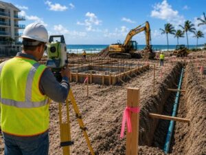
Construction staking isn’t a one-time event. A surveyor sets the first round of stakes, then returns again and again as a project moves forward, because the ground a crew builds on today isn’t the same ground it was during the first walkthrough. That first round turns a paper plan into something a crew can measure against, but dozens of moving parts follow, and each one can throw the layout off just enough to cause a real problem.
Construction Staking Happens at Every Project Phase
A foundation crew needs different marks than a framing crew, and a utility crew laying pipe needs different marks than the team pouring a driveway. Because of that, a surveyor doesn’t set one batch of stakes and disappear. They return as the project shifts from one phase to the next, checking that the marks left behind still match what the current crew needs.
Take a mid-size commercial build as an example. The first staking round sets building corners and grading points. Once excavation wraps up, a second round marks foundation lines. Later, a third round handles utility trenches and finish grade. Skip any of those check-ins, and a crew ends up guessing, which almost never ends well.
Site Changes Can Move Reference Points After Staking
A stake can stay physically in place while the ground around it no longer matches the original survey data. That’s because digging, grading, heavy equipment, and weather all shift soil and elevation once the first staking round is finished. The marker itself usually isn’t the problem. The ground underneath it is.
Digging shifts soil. Grading changes elevation. Heavy machinery compacts or loosens dirt as it rolls across a lot, and rain or wind adds its own version of chaos over time. All of that adds up to a site that looks different from the one the crew first walked. A grading point set during dry weather can read differently after a week of storms. A reference elevation near an excavation site can drift once the surrounding soil settles. So a surveyor’s job isn’t just placing stakes. It’s confirming those points still tell the truth about where things stand today.
Coastal Projects Need Shorter Intervals Between Staking Checks
Tides, storm surge, and shifting sand move reference points faster than inland soil does, so coastal projects need shorter gaps between staking checks to keep construction aligned with the current shoreline. Sand shifts with wind and tide in a way inland soil never does. Storm surge can rework a shoreline overnight, and even routine erosion moves reference points a crew assumed were fixed.
Because of that, coastal builds lean harder on regular staking checks than most inland projects. Skipping a check here doesn’t just risk a crooked wall. It can mean building in the wrong spot entirely once the site has shifted underneath the plan.
Surveyors and Builders Catch Errors Through Regular Communication
Good staking isn’t a surveyor working alone in a corner of the site. It’s a back and forth. Crews report site changes like heavy equipment traffic or storm damage, and surveyors respond with updated marks. That two way check catches problems neither side would notice working alone.
A foreman who notices a missing stake and reports it right away saves everyone a headache. A surveyor who checks in during a busy excavation week does the same thing from the other direction. Neither side catches everything alone, and neither one really should have to.
Regular Construction Staking Reduces Rework Costs
A staking check before a major pour costs a fraction of what it costs to tear out and repour concrete placed at the wrong depth or location. Skipping staking checks feels like a shortcut in the moment, but it rarely turns out that way. A crew working off outdated points might pour a footing in the wrong spot, run a utility line at the wrong depth, or grade a slope that no longer matches the plan.
Builders who schedule regular checks tend to finish closer to budget and closer to schedule, since fewer surprises turn up mid-build. Common points in a project where a staking check pays off include:
- Before excavation begins
- After excavation, before foundation work
- Before a major concrete pour
- Before utility trench work
- Before final grading
Construction staking was never meant to be a single event. It’s a running conversation between the plan and the ground, one that keeps happening for as long as the site keeps changing.
Frequently Asked Questions
What is construction staking?
Construction staking is the process of marking a job site with physical points that match an approved building plan. Those marks guide crews on where to dig, build, or grade throughout a project, not just at the very start.
How often is construction staking needed?
Most builds need a fresh check at every major phase change, such as after excavation, before framing, and again before final grading. Sites with heavy equipment traffic or loose soil often need more frequent checks than a stable, dry lot.
Can construction staking markers be moved?
Yes. Digging, grading, and shifting soil can all move the ground around a marker even if the stake itself stays in place. A surveyor resets those points whenever site conditions change enough to throw off their accuracy.
Who uses construction staking on a job site?
Construction staking supports everyone from excavation crews to foundation teams to utility contractors. Each group relies on marks that match their current phase of work, which is why surveyors return throughout a project instead of staking once and leaving.
Why is construction staking important for coastal projects?
Coastal sites deal with shifting sand, tides, and storm activity that inland lots rarely face. Those factors move reference points faster and more often, so regular staking checks help crews stay accurate even as the shoreline itself keeps changing.
For a free land surveying quote, call us at (954) 250-5780 or send us a message by going here.
Posted in land surveying, land surveyor | Tagged Construction staking
Land Surveying: Estimating the Cost

Copyright (c) 123RF Stock Photos
Land surveying, in short, is the science and art of establishing or re-establishing property corners, property lines and/or boundaries. There are different reasons why someone wants a lot surveyed.
Essentially the most common is to check if a piece of land is vulnerable to flooding, to subdivide a property to sell or deed to family members as well as to determine if there are any encroachments. This may happen if a neighbour disputes that you are using a piece of his lot or viceversa (for more on this, go here).
The Cost of Land Surveying
If you need to have a piece of land surveyed, the first thing that will come to mind is “how much will it cost?”There are plenty of factors determining exactly how much land surveying for your land would cost.
The fact that this type of service must be carried out by an expert contributes a great deal to the overall cost of the service, but choosing a non-professional to survey your land is dangerous and possibly illegal for the non-professional. Because of this you have to take a good look around before settling with a surveying company.
If you must work within a particular budget, discuss this with the surveyor up-front. Very often he may be able to offer cost saving steps to get the work you need done within these cost limits. The form of the land must also be looked into. A square or even a rectangle piece of land is somewhat easier to survey than an odd shaped parcel, or one with many different sides.
With the latter, the surveyor would have to take more time in surveying the curves as well as the bends which means the cost of the service would go higher.
The overall measurements the land is also key factor here. Understand that the cost of land surveying is normally proportionate to the time and effort that the land surveyor would spend on the project. If the land that you’re having surveyed isn’t accessible, or has thick vegetation, then the total price of the survey might go higher.
This is true of the varying weather conditions that might impact the work. Surveying in warm weather is somewhat slower to keep from putting the crew members in danger. Also, most surveying can’t be done in the rain.
When requesting for an estimate, bear in mind that surveyors base the estimate on expected conditions at the site. These conditions could change, bringing about additional costs. Always ask about these potential additional cost scenarios.
All that being said, competitive prices are also to be expected, this is why we recommend deciding on a surveyor based upon his experience and reputation rather than on the price he writes on a piece of paper. Usually it is better to invest a good amount of money on a survey that’s well-done rather than choose a company with a very “affordable” price but have the survey repeated because the results were wrong.
To sum it up, you should always discuss the expenses of the survey before you decide to ask the surveyor to start his work. It’s also wise to receive a contract that lets you know what is expected of the land surveyor. This is one of the most important steps in getting your land surveyed.
For a free land surveying quote, call us at (954) 250-5780 or send us a message by going here.
Posted in land surveying, land surveyor | Tagged cost of land surveying, estimating the cost of land surveying, land surveying cost, land surveying cost Fort Lauderdale