
How UAV Survey Data Improves Earthwork Planning
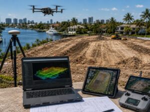
Moving dirt without good ground data is expensive guesswork. A uav survey paired with lidar mapping gives developers exact elevation numbers before the first excavator shows up. This matters even more in Fort Lauderdale. Marine and waterfront access shapes so many sites here. Grading near water leaves very little room for error.
Why Earthwork Numbers Have to Be Right the First Time
Earthwork decisions live or die on elevation numbers. How much dirt needs to move. Where it needs to go. Whether the site drains correctly once grading wraps up.
Old survey data leads to bad numbers. Rough estimates do too. Bad numbers mean hauling too much fill, or not enough. Both mistakes cost real money.
A current uav survey removes the guessing. It shows what the site looks like right now. Not what an old plan assumed years ago.
What a Drone Actually Sees From Above
A drone flight over a site collects detailed ground data fast. It covers ground that would take a survey crew far longer to walk on foot.
One Flight Covers the Whole Parcel
A ground crew measures point by point. A drone captures the entire parcel from above in one pass. This gives engineers a full picture of existing grade. Not just a handful of sample points scattered across the site.
Lidar Adds the Elevation Detail Photos Miss
Photos show what a site looks like. Lidar mapping shows the numbers behind it. Every point on the surface gets a measured height. Often accurate to a few centimeters.
This detail matters most on sites with small grade changes. A tiny error there can throw off an entire earthwork plan.
Getting Cut and Fill Numbers Right Before Digging Starts
Cut and fill volumes drive both the schedule and the budget on an earthwork project. Get these numbers wrong and you either pay for extra material or run short halfway through the job.
With lidar-based elevation data, engineers calculate exactly how much material needs to move. They also know where it needs to go. This happens before any equipment reaches the site. A rough estimate becomes a real number the team can plan around.
Testing different grading options gets easier too. A team can compare two or three final grade plans against the same base data. Then they pick the one that balances cost and drainage performance best.
Catching Water Problems While They’re Still Just Lines on a Screen
Grading mistakes often show up later as drainage problems. Water pools where it shouldn’t. A low spot floods after the first heavy rain.
Lidar data lets engineers model how water will move across a planned grade. This happens before construction starts. A low spot gets caught on paper. Fixing it there costs almost nothing, just an adjusted design line. Fixing it after paving or landscaping is finished costs far more.
Working Near Water Changes the Planning Math
Fort Lauderdale has more waterfront and canal-adjacent parcels than most inland markets. That adds planning steps a standard earthwork job never has to think about.
Grading Close to Seawalls and Canal Edges
Grading near a seawall or canal bank takes careful elevation planning. Too much fill near the edge adds unwanted weight against the seawall. Too little grade change leaves water sitting right where the property meets the water. Accurate elevation data across this transition zone helps engineers strike the right balance.
Keeping Docks and Boat Access Usable During Construction
Some sites already have dock access, boat lifts, or marine easements in place. Grading plans need to keep that access working during and after construction. A uav survey captures these features along with the rest of the site. That means the earthwork plan accounts for them from day one, instead of working around them later as an afterthought.
Checking the Finished Grade Against the Plan
Earthwork rarely goes exactly as planned. Equipment settles material differently than expected. Weather affects how soil compacts. A follow-up drone flight after grading lets engineers compare the finished surface against the original design.
This comparison shows whether the site matches the intended grades. It also flags any area that needs correction before the next construction phase begins. Catching this early costs far less than finding a grading problem once a building pad or road base is already in place.
A Simple Way to Put This Data to Work
A few practical steps help developers get real value from this kind of data on an active project.
- Fly the site before design work starts, to set an accurate baseline.
- Use the elevation data to test a few grading options before picking one.
- Bring the drainage engineer in early, so grading and stormwater planning happen together, not as separate steps.
- Fly again after major grading work, to confirm the finished grade matches the plan.
- Keep both flight datasets on file. Comparing before and after data helps document the work for permitting or future site changes.
Frequently Asked Questions
How is a UAV survey different from a traditional ground survey for earthwork planning?
A UAV survey captures detailed data across the entire site from above, while a traditional ground survey measures selected points from the surface. For earthwork planning, UAV data can provide broader coverage in less time, although ground measurements may still be used for control and verification.
How accurate is LiDAR mapping for calculating cut-and-fill volumes?
LiDAR mapping can produce highly detailed elevation data when the site is surveyed and controlled properly. This information supports reliable cut-and-fill calculations for many commercial and residential earthwork projects.
Does waterfront property require different earthwork planning than an inland lot?
Yes. Waterfront properties may require additional planning around seawalls, canal banks, drainage patterns, soil conditions, and marine access. These features can affect grading limits, fill placement, and overall site stability.
Can a UAV survey help prevent drainage problems after grading?
Yes. Elevation data collected before construction allows engineers to model proposed drainage patterns and identify low areas or potential pooling points. This makes it easier to adjust the grading plan before work begins.
How soon after grading should a follow-up drone flight be completed?
A follow-up flight should be completed soon after a major grading phase is finished. This allows the project team to compare the completed surface with the design and correct any elevation differences before the next stage of construction starts.
For a free land surveying quote, call us at (954) 250-5780 or send us a message by going here.
Posted in land surveying, land surveyor | Tagged LiDAR Mapping