What Is a Topographic Survey and Why Does It Matter?
 If you are planning a pool, home addition, driveway, or new construction project, there is one document you will probably hear about quickly: a topographic survey.
Most homeowners do not hear about it until they are applying for permits or planning construction. Then suddenly everyone asks for a “topo survey,” and it can get confusing fast.
What Is a Topographic Survey?
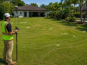
A topographic survey is a detailed map that shows the shape, elevation, and features of a property. It records slopes, drainage paths, structures, trees, and ground elevations.
Often called a “topo survey,” it measures land in three dimensions: length, width, and elevation.
Unlike a boundary survey, which only shows property lines, a topo survey reveals what the land actually looks like and how water moves across it.
The survey maps features such as:
- Hills and slopes
- Low spots
- Drainage paths
- Trees
- Buildings
- Driveways
- Utilities
- Fences
The final survey includes contour lines. These lines connect areas with the same elevation.
- Lines close together = steeper slope
- Lines farther apart = flatter land
In Fort Lauderdale, many properties are only 1 to 5 feet above sea level. Because the area is so flat, even a few inches of elevation can affect drainage and flooding.
What Does a Topographic Survey Show?
A topographic survey shows elevation changes, contour lines, structures, drainage features, utilities, trees, and important property information.
A professional topo survey usually includes the following:
Elevation Information
- Contour lines
- Spot elevations at important points
- Finished floor elevations
- NAVD88 benchmark elevations used by FEMA
Property Features
- Homes and buildings
- Trees and landscaping
- Fences and walls
- Driveways and sidewalks
- Pools and patios
Drainage Features
- Swales and ditches
- Storm drains and catch basins
- Water flow direction
- Low areas where water collects
Property Details
- Property boundaries
- Easements
- Setbacks
- Flood zone references
How Is a Topographic Survey Done?
A licensed surveyor uses GPS and surveying equipment to collect elevation points across the property. The data is then turned into a detailed contour map.
Here is how the process usually works:
- Records Research. The surveyor reviews deeds, plats, and past surveys.
- Field Work. A survey crew visits the property and collects measurements using GPS and total station equipment.
- Feature Mapping. Structures, trees, drainage features, and utilities are recorded.
- CAD Drafting. The survey data is imported into computer software to create contour maps.
- Quality Review. A licensed Professional Surveyor and Mapper (PSM) reviews the work.
- Final Delivery. The signed and sealed survey is delivered as a PDF or CAD file.
For most homes in Fort Lauderdale, field work takes 1–3 days, with final delivery usually within 3–7 business days.
When Do You Need a Topographic Survey?
In Fort Lauderdale, topographic surveys are often required before construction, drainage work, pool installations, and permit approval.
Before Construction Projects
Broward County often requires topographic information for:
- Home additions
- Pools and spas
- Garages
- Driveways
- Retaining walls
- Grading projects
- New home construction
Without a topo survey, engineers and architects cannot properly design drainage plans.
When Installing a Pool
This is one of the most common reasons homeowners need a topo survey.
The survey helps determine:
- Where rainwater will flow
- Whether water will collect near the pool
- How grading should be designed
- Whether drainage could affect neighboring properties
When You Have Drainage Problems
If your yard floods during heavy rain, a topo survey can help identify the cause.
It shows:
- Low spots
- Drainage patterns
- Water flow direction
- Areas where runoff collects
An engineer can then use the survey to design drainage improvements.
For FEMA Flood Zone Issues
If you want to challenge a FEMA flood zone designation or apply for a LOMA, elevation information is required.
A topo survey provides the elevation data needed for the application.
When an Architect or Engineer Requests It
Architects and civil engineers use topo surveys as the base map for site design.
Without accurate survey data, they cannot properly design the project.
Why Topographic Surveys Matter So Much in South Florida
South Florida is extremely flat, so even small elevation changes can affect flooding and drainage.
In many places, a few inches of elevation difference may not matter much. In Fort Lauderdale, it can make a huge difference.
Important facts about the area:
- Many properties sit only 1–5 feet above sea level
- A difference of 6 inches can change drainage patterns
- Most areas in Fort Lauderdale face some level of flood risk
- Broward County continues investing in drainage and canal improvements
A topographic survey helps property owners understand how water behaves on their lot before construction begins.
How Much Does a Topographic Survey Cost?
Residential topographic surveys usually cost between $800 and $3,500 depending on the size and complexity of the property.
Typical price ranges include:
Survey Type | Typical Cost |
Residential topo survey | $800 – $2,000 |
Topo + boundary survey | $1,200 – $2,800 |
Commercial topo survey | $2,500 – $6,000+ |
Drone-assisted topo survey | $1,500 – $4,000 |
Several things affect cost:
- Lot size
- Trees and vegetation
- Number of structures
- Property access
- Rush turnaround requests
- Combining services with a boundary survey
Topographic Survey vs. Other Survey Types
A topographic survey shows elevations and land features. Other surveys focus on different property details.
Survey Type | What It Shows | Common Use |
Topographic Survey | Elevations and drainage | Construction and permits |
Boundary Survey | Property lines | Fences and property disputes |
Elevation Certificate | Building elevation vs flood level | Flood insurance |
ALTA Survey | Detailed commercial survey | Commercial real estate |
As-Built Survey | Completed construction layout | After construction |
Many homeowners think their old boundary survey is enough for permits. In Broward County, it usually is not. A topographic survey provides the elevation and drainage information required for many projects.
Frequently Asked Questions
Do I need a topographic survey for a fence?
Usually no. Most fence projects only require a boundary survey unless grading or retaining walls are involved.
How long does a topographic survey take?
Most residential surveys take 3–7 business days from field work to final delivery.
Can I use an old topo survey?
Sometimes. However, many building departments require newer surveys, especially if the property has changed.
What is the difference between a topo survey and a grading plan?
A topographic survey records existing land conditions. A grading plan is created by an engineer to show how the land will be changed.
Does a topo survey show underground utilities?
It shows visible utility features, but separate utility locating services may still be needed for buried lines.
For a free land surveying quote, call us at (954) 250-5780 or send us a message by going here.
Posted in land surveying, land surveyor |